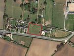
Land for sale in Littleover, Derbyshire DE23


* Calls to this number will be recorded for quality, compliance and training purposes.
Property features
- Greenfield site
- Located on the southern outskirts of the city of Derby
- Potential for development
- Subject to obtaining necessary planning consents
- On the loop road around Heatherton Village
- For sale freehold by private treaty
- Inviting conditional and unconditional offers
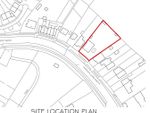
- Approximately 0.71 acres (0.29 hectares
Property description
Strategically located land with potential for development (subject to obtaining planning permission).<br/><br>
<b>Situation and Description</b>
The Property is located in the village of Littleover, a southern suburb of Derby and has a population of 15,122 as per the 2021 census. The Property is laid to permanent pasture and the boundary features are generally mature hedges.
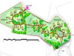
The Property is accessed via Hollybrook Way to the north of the Property. On the western boundary of the Property is Hollybrook Medical Centre and then beyond this is Aldi supermarket. On the eastern boundary of the Property is the Haven Christian Centre. The southern boundary is bordered by land which has an allocation in the Derby City Local Plan for the development of 900 dwellings (includes land to the north west – north of Rykneld Road).
Transport links are good with the A38 located approximately a mile to the south west of the Property and Junction 4 of the A50 (Derby Southbound) is located approximately 2.5 miles to the south of the Property which provides a link to the M1.
<b>Planning Policy Background</b>
The Property is located within Derby City Centre Local Planning Authority. The Development Plan for Derby City Council currently comprises:
• Saved Policies of the City of Derby Local Plan Review (Adopted 2006).
• The Rykneld Road Housing Development spd (Adopted January 2008).
• The Derby City Local Plan Part 1 Core Strategy (Adopted January 2017).
<b>Adopted Planning Policy</b>
The Derby City Local Plan Part 1 Core Strategy (Adopted January 2017) plans for the period 2011 to 2028.
The Council’s Policies Map identifies the land south of Hollybrook Way as lying within a defined ‘Neighbourhood Centre’ and within a ‘Safeguarded Area Around Aerodromes.’ The southern boundary of the Property adjoins a strategic housing allocation known as Rykneld Road.
Key policies of relevance to the Property from the Council’s Development Plan are set out below:
Policy CP12 – Centres states that the City Council will ‘seek to sustain and enhance the vitality, viability and competitiveness of defined centres and prioritise them as the most accessible and sustainable way of meeting everyday shopping and service needs’. The Property is located within a Neighbourhood Centre, of which the Council defines meet the needs for small scale retail and services of small local catchments. Consequently, the policy requires development in these areas to be ‘small scale and have regard to maintaining access to local shopping and other facilities that meet day to day needs’. Adopted planning policy outlines that the Council will support proposals that:
• Meet local shopping and service needs while supporting the vitality and viability of the Centre. Uses which would undermine this objective, either as a result of loss of retail function or through the impact on the character or environment of the centre will be resisted.
• Help to combat long term and persistence vacancy. The Council may require applicants to submit appropriate evidence which demonstrates that the unit has been marketed for retail uses for a reasonable period of time and/or longer suitable for shopping uses.
• Encourage competition and consumer choice.
• Help to maintain vibrant and coherent shop frontages.
• Respect, and are compatible with, the scale, role, character, and function of the centre and would not have an unacceptable impact on the vitality and viability of other centres in the hierarchy.
• Help secure physical improvements to the centre, particularly where they will help to create high quality spaces that are accessible by all modes of transport.
Policy AC20 – Rykneld Road relates to both the land immediately to the south of the Property and another parcel of land to the north of Rykneld Road. Both sites together are allocated for 900 dwellings. Policy AC20 outlines that the Rykneld Road allocation sites will also form part of a larger growth area which will include the development of approximately 1,200 new homes on the land within South Derbyshire local planning authority (the Highfields Farm allocation).
The policy sets out various criteria which the developments on the Rykneld Road sites will need to follow. Of particular relevance to the Property, the criteria states that the Council will require ‘the expansion of Heatherton Neighbourhood Centre to provide extended shopping facilities and community uses, including a small supermarket. Expansion should complement the provision of similar facilities within the South Derbyshire element of the development’. As such, this policy criteria in addition to the provisions of Policy CP12 make it clear that the Council’s intention is to both protect and expand the Neighbourhood Centre which the site south of Hollybrook Way forms part of.
<b>The Rykneld Road Housing Development Supplementary Planning Document (spf) </b>
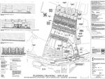
(Adopted January 2008) was prepared as the land at Rykneld Road was previously allocated for housing development within the 2006 Derby Local Plan (under former Policy H9 which was replaced by Policy AC20). Within Section 2 of the spd, an Opportunities & Constraints Plan is included which identifies the land south of Hollybrook Way as the site of a ‘Potential Expansion of Neighbourhood Centre’, and the location of a ‘Potential Vehicular Access Point’ for the development.
The City of Derby Local Plan Review (Adopted 2006) Contains Policy E30 – Safeguarded Areas around Aerodromes. As the Property lies within the Safeguarded Area, the provisions of this policy are of relevance.
Policy E30 outlines ‘Within the safeguarded area new development will only be permitted where it will not result in a serious hazard to aircraft’. In considering application for planning permission, the Council will have particular regard to:
• The height and design of development.
• The likelihood of it creating a bird hazard.
• The likely impact of navigational radio waves and telecommunications systems for the purposes of air traffic control and aircraft movements.
Whilst the above provisions of the Policy E30 need to be considered by any development proposals in the Safeguarded Area, they do not compromise an overriding constraint to development.
<b>Emerging Planning Policy</b>
On the 8th December 2021, the Council’s Cabinet approved the commencement of work on a new Local Plan for Derby. The new Plan will cover the period up to 2040. The new Plan will address challenges facing Derby, including:
• Accommodating the Government’s revised housing requirements (Note: A 35% uplift in housing requirement was attributed to the twenty largest Cities and Urban Centres in England, including Derby).
• The need to address climate change.
• The City’s recovery from the covid-19 pandemic.
• The regeneration of the city centre.
<b>Neighbourhood Plan</b>
The Property does not lie within a designated Neighbourhood Plan area.
<b>Planning History</b>
According to the Council’s online planning records, the Property has formerly been included within the application boundary associated with the outline planning applications submitted on the adjoining strategic housing allocation site as follows:
Application reference: 03/08/00445 - Residential development of land also including Business Units (Use Class B1), Retail Unit (Use Class A1) other Retail, Commercial and Community Uses (Use Classes A1, A2, A3, A4, D1 and D2), Site for Primary School, formation of Vehicular access, provision of Open Space, landscaping services, and associated works, Land east of Rykneld Road, Littleover Derby – application withdrawn November 2008.
Application reference: 01/11/00023 – Residential development (up to 800 dwellings), Business units (Use class B1), Retail Foodstore (Use Class A1), Community Facilities (Use Class D1 and D2), Commercial Uses (Use Classes A1, A2, A3, A4 and A5), Primary School (Use Class D1) and formation of vehicular access to Rykneld Road and Hollybrook Way, Land east and west of Rykneld Road, Littleover, Derby – Pending consideration.
Application reference: 20/00741/ful – Erection of a retail unit (Use Class A1) with a new access and car parking, Land at Rykneld Road, Derby, DE23 4AN, approved 19th February 2021, relates to the newly constructed Aldi Supermarket within the adjoining Rykneld Road allocation site.
<b>Environmental and Heritage Consideration</b>
According to the Environment Agency flood risk map, the Property is located in Flood Zone 1 (low probability of flooding).
It is our understanding that there are no designated heritage assets on, or within immediate proximity to the Property.
It is our understanding that the property is not subject to any statutory environmental designations.
<b>Access</b>
Part of the Property comprises a vehicular access to the neighbouring Hollybrook Medical Centre. It is envisaged that any development on the Property would need to be served by a new access either through the land currently serving the Medical Centre or via a new separate access.
<b>Tenure and Possession</b>
The Property is held under Freehold under Land Registry numbers DY28487, DY46356 and DY19161. The Property is offered for sale Freehold.
<b>Ransom Strip</b>
As part of the disposal, the Landowner will retain a one metre ransom strip along the eastern, southern and western boundaries of the Property.
<b>Mineral, Sporting and Timber Rights</b>
As far as they are owned, the mineral, sporting and timber rights are included in the freehold sale. Interested parties are to undertake their own investigations and satisfy themselves on these rights.
<b>Rights of Way, Wayleaves and Easements</b>
The Property will be sold subject to and with the benefit of all Rights of Way, Wayleaves and Easements, whether mentioned in these particulars or not.
<b>Services</b>
Prospective purchasers must satisfy themselves as to the availability of services and future connections.
<b>VAT</b>
Any guide price quoted or discussed is exclusive of VAT. In the event that a sale of the Property, or any part thereof, or any right to it becomes a chargeable supply for the purposes of VAT, such tax will be payable in addition to the sale price.
<b>Viewings</b>
Strictly by appointment through the selling agent. The Property must not be entered unless an appropriate risk assessment has been undertaken and due care must be taken at all times.
The Landowner nor their agent take any responsibility for loss of injury on the Property and all viewings are undertaken at that person’s own risk.
<b>Local Planning Authority</b>
Derby City Council, Council House, Corporation Street, Derby, DE1 2FS.
<b>Plans, Schedules and Boundaries</b>
The plans and schedules within these particulars are based on ordnance survey data and are provided for reference only. They are believed to be correct, but accuracy is not guaranteed. The Purchaser shall be deemed to have full knowledge of all the boundaries and extent of ownership. Neither the Vendor nor their agent will be responsible for defining boundaries or the ownership thereof.
<b>Offer Requirements</b>
We are inviting both unconditional and conditional offers on the Property. Should your offer be conditional, please be very clear on the conditions included and whether it includes any pre-exchange qualifications.
Property info
For more information about this property, please contact
Fisher German Ashby De La Zouch, LE65 on +44 1530 658941 * (local rate)
Disclaimer
Property descriptions and related information displayed on this page, with the exclusion of Running Costs data, are marketing materials provided by Fisher German Ashby De La Zouch, and do not constitute property particulars. Please contact Fisher German Ashby De La Zouch for full details and further information. The Running Costs data displayed on this page are provided by PrimeLocation to give an indication of potential running costs based on various data sources. PrimeLocation does not warrant or accept any responsibility for the accuracy or completeness of the property descriptions, related information or Running Costs data provided here.
Properties on the market nearby


Marketed by
Fisher German Ashby De La Zouch
(view all properties)
The Estate Office Norman Court, Ashby De La Zouch, LE65 2UZ
- Member of:
-

-

-
